Covering longer distances each day and being more immersed in the landscape – the Malbunka is a more substantial journey appropriate for more experienced (or more determined!) trail runners.
Stage Summary
- Stage 1: 20km around Alice Springs, from the Old Telegraph Station to the Mercure
- Stage 2: 41km from Simpsons Gap to Standley Chasm
- Stage 3: 33km from Birthday Waterhole turn-off to Standley Chasm.
- Stage 4: 34km from Ochre Pits to Ellery Creek Water Hole.
COURSE MAPS
CLICK HERE for a full screen version of the interactive Terranium Map below (this map displays the course for each day via the menu at top left). Seperate PDF maps for each stage are linked with the stage notes below.

MAPS ON YOUR PHONE: To load the course maps on your phone for off-line usage, simply scan or tap the QR CODE to install the Avenza mapping app (if not already installed) and download all the Malbunka course maps to your phone in one hit. Separate GPX files to import into your own mapping app / watch are linked in the stage notes below
The Malbunka – STAGE 1
| Time and Date: | 5:20pm on 14 August 2026 |
| Start location: | The Old Telegraph Station in Alice Springs |
| Finish location: | The Mercure Hotel |
| Length: | 19.5km. Elevation: 220m up and 220m down. |
| Water points: | Approx 14.3km pt Runners must start with a minimum of 750ml hydration with you |
| Cut off times: | Start time + 2hrs 15min at the water point (13.5km pt) |
| Difficulty rating: | Medium |
COURSE MAP / FILES: CLICK HERE for a PDF map of Malbunka Stage 1. CLICK HERE for the GPX file for Malbunka Stage 1.
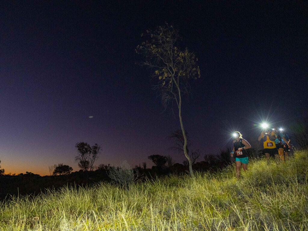
Runners start just before sunset and then run through twilight and into darkness for the unique experience of running through the desert at night time, under a universe of stars and the outback world around you. All runners must start with a head torch that you can turn on when darkness descends (at 6:15pm).
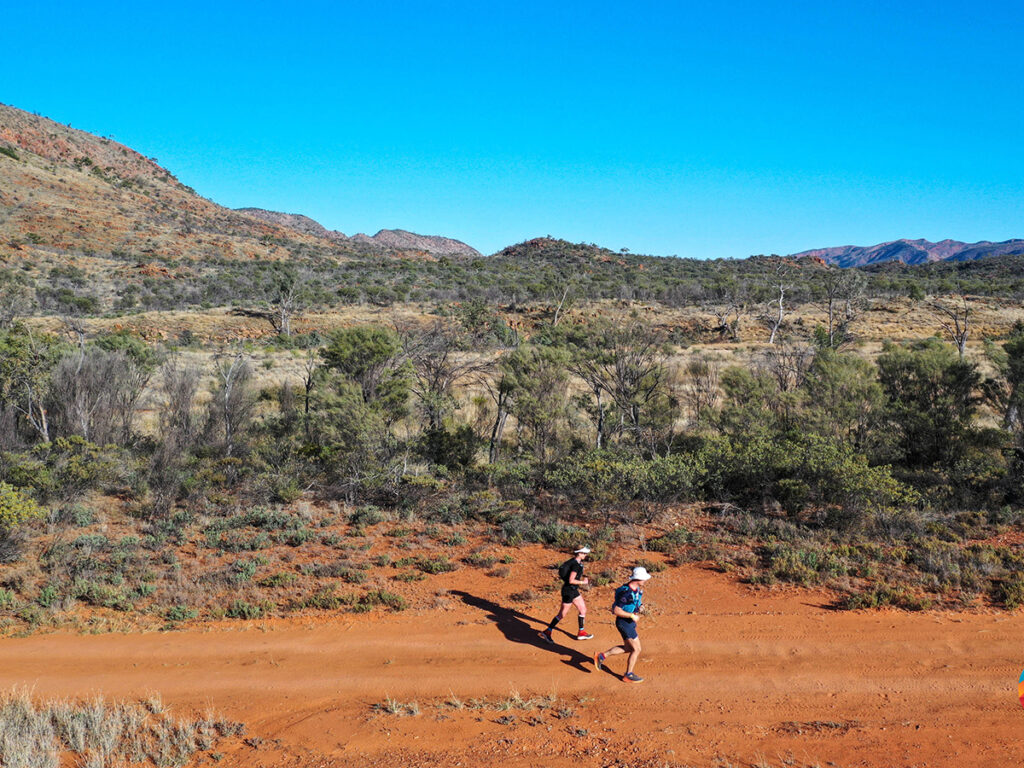
The course starts amidst the ghost gums and the original Alice Spring at the Old Telegraph Station north of the township. The course follows a scenic route along some of the running and MTB trails that surround the town, including many spectacular sections providing views over the surrounding ranges as they are illuminated by the sunset light. Continuing into darkness, the stage finishes on the grass at the Mercure Hotel.
These trails are not overly technical (with the exception of a couple of short sections), but they do have a great sense of ‘flow’ and will provide a terrific introduction to the Central Australian terrain you’ll enjoy over the days to come.
The Telegraph Station is just 5km from the centre of Alice Springs and a shuttle bus will operate to the start line.
The Malbunka – STAGE 2
A very challenging but incredibly scenic run that links two of the MacDonnell Range’s most popular (and impressive) landmarks.
| Time and Date | 6:40am on 15 August, 2026 |
| Start location: | Simpsons Gap – 25mins drive from Alice Springs |
| Finish location: | Standley Chasm – 45mins drive from Alice Springs |
| Length: | 41km. 1,300m up and 1,075m down. |
| Water point: | Runners must start with a minimum of 2 lt hydration. WP1 at 16km pt at Mulga Camp. WP2 at 26km pt at the Jay Creek shelter. Runners must depart with a minimum of 3 lt hydration WP3 at the 34km pt at the western end of the ‘High Route’ ridge line. WP3 should be considered as an emergency Water Point only. Max 1lt per runner. |
| Cut off times | Start Time + 5hr45min at Jay Creek WP2 (26km pt) |
| Difficulty rating: | Starts off easy and gradually increases in difficulty. Last 10km is very difficult and technical. |
COURSE MAP / FILES: CLICK HERE for a PDF map of Malbunka Stage 2. CLICK HERE for the GPX file for Malbunka Stage 2.
Stage 2 starts on the dry river bed at picturesque Simpsons Gap. The course can basically be split into two halves, the first half through to Water Point 2 at the 26km point is quite flat and fast, providing comfortable running through open country and nice scenery.
The second half from the 26km point to the finish is a lot harder with some very technical running over rough ground and is significantly slower going than the first half. The course climbs up a rough rocky ridge to the top of the Chewings Range providing some incredible views across Central Australia, before descending into a rough and scrambly valley below. (The descent is very technical and the last 5km along the valley is also quite rough with a short section of ‘rock climbing’.) The last 10km provide slow going until you reach the well earnt finish line at the Standley Chasm café.
The landscape, the views and the terrain are all absolutely spectacular from start to finish – this is the jewel stage for many runners.
IMPORTANT NOTE: Competitors please note this is the hardest stage of the event with long rocky sections providing slow going and many ascents that can prove tough in the heat. Please come prepared to embrace everything the course throws at you.
The Malbunka – STAGE 3
A spectacular stage that is often a highlight for many runners. It covers a very rugged and remote section of the Larapinta Trail, in some ways similar to Stage 2 (but a little bit easier).
| Time and date | 7:20am on 16 August, 2026 |
| Start location: | Birthday Waterhole track / Red Centre Way road junction – 40mins drive from Alice Springs |
| Finish location: | Standley Chasm – 45mins drive from Alice Springs |
| Length: | 33km – elevation 870m up, 760m down |
| Water point: | WP1 at 14km point at Birthday Waterhole Runners must depart WP1 with a minimum of 3 lt of hydration |
| Cut off times | Start Time + 2hr30min at Birthday Waterhole (14km pt) |
| Difficulty rating: | Starts off easy then has a steep climb in the middle. Medium / hard difficulty and technical |
COURSE MAP / FILES: CLICK HERE for a PDF map of Malbunka Stage 3. CLICK HERE for the GPX file for Malbunka Stage 3.
Runners commence at the Birthday Waterhole Track / Red Centre Way road junction and run for approx. 14km along the undulating 4WD track as it winds its way across the flats and crosses a few dry creeks before arriving at Birthday Creek Waterhole. This section is very runnable and rewarding as you make your way towards the ranges.
Past the water point the course picks up the Larapinta Trail and skirts the base of some ridges before a very steep and tough climb up to the iconic Brinkley Bluff – the course climbing 550m in just 3km as it zig-zags its way up the side of this steep ridge, passing many false summits and steep drops in the process. The views from the top make it well worth it as you are high up in the Chewings Ranges with views across the continent.
From the summit it is largely ‘all downhill’ for 10km to the finish line at the Standley Chasm café although the highly technical terrain and loose rock make it a taxing descent through Reveal Saddle to the finish arch.
The Malbunka – STAGE 4
This scenic stage visits one of the MacDonnell Ranges’ favourite lookouts before finishing at Ellery Creek water hole for a swim.
| Time and Date | 7:00am on 17 August, 2026 |
| Start location: | Ochre Pits – 1hr10mins drive from Alice Springs |
| Finish location: | Ellery Creek Waterhole – 1hr drive from Alice Springs |
| Length: | 34km – elevation: 1,000m up and 910m down |
| Water points: | WP1 at Serpentine Chalet Dam 6km pt. WP2 at Serpentine Gorge 21km pt All runners must depart each water point with a minimum of 2 lt hydration. |
| Cut off times | Start time + 4hr45min at WP2 at Serpentine Gorge |
| Difficulty rating: | Medium – the last 10km is very technical and can be hot |
COURSE MAP / FILES: CLICK HERE for a PDF map of Malbunka Stage 4. CLICK HERE for the GPX file for Malbunka Stage 4.
The start is at the ancient Ochre Pits, used by indigenous communities as a quarry for their rock paintings and body art. Head north for 3.5km runners then turn right (east) on the Larapinta Trail and continue along the undulating terrain as it flanks the ridges to go past Serpentine Chalet Dam at the 6km mark. At the 9km mark, the trail makes a sharp turn up as you climb to the spectacular Counts Point lookout on the ridgeline. Runners must complete a short 700m out and back to visit the lookout and get their name ticked off.
The spectacular running continues along the ridgeline and then drops down to the Water Point at Serpentine Gorge at 21km and continues along the undulating trail below the ridgeline to the ultimate finish line at the Ellery Creek Waterhole. This last section from WP2 to the finish is very harsh, sharp and rocky, so you must keep concentrating all the way to the finish.
We will have a ‘beach party’ set up at the waterhole with chairs, shade, music, food and drinks – and of course the magnificent waterhole to swim in – to help celebrate the end of Run Larapinta. It will be a finish line to remember!
GPS Course file – MANDATORY FOR ALL COMPETITORS
All competitors MUST have the maps for ALL 4 STAGES loaded into a mapping app on their phone. We recommend runners use any of the free commercially available mapping apps such as Avenza (as explained below) or AllTrails, Gurumaps, Gaia GPS, Komoot, Maps.me
OUR RECOMMENDATION: Is to load the maps into the Avenza app. To do so simply scan or tap the QR CODE to install the Avenza mapping app (if not already installed) and download all the Malbunka course maps to your phone in one hit. The maps will work when you have no phone reception out on the course.
ENTRY QUALIFICATIONS AND REQUIREMENTS
The Malbunka – Entry Qualifications
To be able to participate in any or all stages of the Malbunka, runners must have completed any one of the following between August 2024 and the 2026 race:
- A 50km trail running race OR
- A 100km trail running race OR
- A marathon in a time of under 4.5 hours (this may be a road or trail marathon on flat terrain)
- Previously completed the Malbunka at Run Larapinta.
We have set in place these requirements to help ensure runners have the required skills and experience to complete the Malbunka stages safely and within the cut off times. You will be asked to provide a URL link to your race result as evidence that you satisfy these requirements during the online entry process (so have it handy when entering). If you have not yet completed these requirements but intend to do so before the Run Larapinta you can enter TBA in the field whilst entering and advise us at a later date. Further details on qualifying available here.
UTMB Qualifying Race & ITRA Points

The Malbunka course (4 stages) of Run Larapinta is with the ITRA and UTMB as an official qualifying race for the UTMB World Series with a value of 3 points and is also awarded 3 ITRA points. For further information on UTMB click here.